
File:Remote Near Oceania Skirgaard 2020.png

Size of this preview: 800 × 541 pixels. Other resolutions: 320 × 217 pixels | 640 × 433 pixels | 1,024 × 693 pixels | 1,280 × 866 pixels | 2,560 × 1,732 pixels | 9,777 × 6,616 pixels.
Original file (9,777 × 6,616 pixels, file size: 4.87 MB, MIME type: image/png)
| This is a file from the Wikimedia Commons. Information from its description page there is shown below. Commons is a freely licensed media file repository. You can help. |
Summary
| Description |
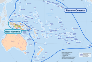
English: Map of Oceania showing the regions of Near and Remote Oceania as proposed by Pawley & Green (1973). The distinction is based on biodiversity and geology. Coloured dots represent languages, colored by language family (based on Glottolog 3.0 with some modification). Buffer zones are based on an approximation of overnight voyages, 100 miles. Map created by CartoGIS at the Australian National University, with borders and labels or Near and Remote Oceania added by Skirgård. Map was first published in Skirgård, H. (2020). Multilevel dynamics of language diversity in Oceania. PhD DissertationCanberra: Australian National University. |
| Date | |
| Source | Own work |
| Author | Marshagreen |
Licensing
I, the copyright holder of this work, hereby publish it under the following license:
This file is licensed under the Creative Commons Attribution-Share Alike 4.0 International license.
- You are free:
- to share – to copy, distribute and transmit the work
- to remix – to adapt the work
- Under the following conditions:
- attribution – You must give appropriate credit, provide a link to the license, and indicate if changes were made. You may do so in any reasonable manner, but not in any way that suggests the licensor endorses you or your use.
- share alike – If you remix, transform, or build upon the material, you must distribute your contributions under the same or compatible license as the original.
File history
Click on a date/time to view the file as it appeared at that time.
| Date/Time | Thumbnail | Dimensions | User | Comment | |
|---|---|---|---|---|---|
| current | 10:21, 30 March 2024 | | 9,777 × 6,616 (4.87 MB) | Marshagreen | Uploaded own work with UploadWizard |
File usage
The following pages on the English Wikipedia use this file (pages on other projects are not listed):