
Portal:Australian roads
Portals → Technology → Transport → Roads
.jpg)
This portal is designed to give an overview of articles associated with the roads in Australia, predominantly with a focus on the roads themselves, but also on their history, associated infrastructure, and other related topics.
Work on the portal and its articles is managed at WikiProject Australian Roads. We are happy to support new editors who are interested in this subject area and to advise them on the creation and improvement of articles. – Join us!

National topics

Northern Territory
- Lists: Highways • Road routes
- Categories: Roads (Highways • Roads in Darwin)
National highways
Highways
Major urban roads
Outback tracks and numbered state routes

New South Wales
- Lists: Highways • Road routes
- Categories: Roads (Highways • Streets in Sydney)
Motorways
National highways
Highways
- Barrier Highway
- Bradfield Highway
- Bruxner Highway
- Carnarvon Highway
- Castlereagh Highway
- Cobb Highway
- Cumberland Highway
- Great Western Highway
- Gwydir Highway
- Hume Highway
- Illawarra Highway
- Kamilaroi Highway
- Kings Highway
- Mid-Western Highway
- Mitchell Highway
- Monaro Highway
- Murray Valley Highway
- Olympic Highway
- Oxley Highway
- Pacific Highway
- Princes Highway
- Prospect Highway
- Riverina Highway
- Silver City Highway
- Snowy Mountains Highway
Numbered routes in Sydney
Major interchanges

Australian Capital Territory
- Lists: Road infrastructure • Road routes
- Categories: Roads (Highways • Streets)
Controlled-access roads
Limited-access roads
- Barry Drive
- Barton Highway
- Belconnen Way
- Canberra Avenue
- Commonwealth Avenue
- Constitution Avenue
- Drakeford Drive
- Fairbairn Avenue
- Federal Highway
- Ginninderra Drive
- Gungahlin Drive
- Horse Park Drive
- Hindmarsh Drive
- Kings Avenue
- Kings Highway
- Limestone Avenue
- Majura Road
- Monaro Highway^
- Northbourne Avenue
- State Circle
- Tharwa Drive
- Vernon Circle
- Yamba Drive
Major interchanges

Queensland
- Lists: Highways • Road routes
- Categories: Roads (Highways • Roads in Brisbane)
Freeways
- M1
- M2
- M3
- M4
- M5
- M6
- M7
- Smith Street Motorway
- Sunshine Motorway
National highways
Highways
- Balonne Highway
- Barwon Highway
- Brisbane Valley Highway
- Burnett Highway
- Bunya Highway
- Capricorn Highway
- Captain Cook Highway
- Carnarvon Highway
- Castlereagh Highway
- D'Aguilar Highway
- Dawson Highway
- Donohue Highway
- Flinders Highway
- Gillies Highway
- Gold Coast Highway
- Gregory Highway
- Isis Highway
- Kennedy Highway
- Leichhardt Highway
- Mitchell Highway
- Moonie Highway
- Mount Lindesay Highway
- Mulligan Highway
- Palmerston Highway
- Peak Downs Highway
- Scenic Highway
- Wide Bay Highway

South Australia
- Lists: Highways • Road routes
- Categories: Roads (Highways • Roads in Adelaide)
Freeways
- M1 South Eastern Freeway
- M2 North-South Corridor
- Northern Expressway
- Northern Connector (under construction)
- North–South Motorway (in progress)
- Southern Expressway
- A9 Port River Expressway
Interstate highways
Highways
- Anzac Highway
- Augusta Highway
- Birdseye Highway
- Browns Well Highway
- Cameron Highway
- Copper Coast Highway
- Flinders Highway
- Gawler Bypass Road
- Glenelg Highway
- Goyder Highway
- Horrocks Highway
- Karoonda Highway
- Lincoln Highway
- Main South Road
- Ngarkat Highway
- Playford Highway
- Port Wakefield Road
- Riddoch Highway
- Salisbury Highway
- Southern Ports Highway
- Spencer Highway
- St Vincent Highway
- Thiele Highway
- Tod Highway
- Victor Harbor Road
- Wilkins Highway
- Wimmera Highway
- Yorke Highway

Victoria
- Lists: Highways • Alphanumeric road routes (Numeric road routes)
- Categories: Roads (Highways)
Freeways
- M1
- M2
- M3
- M8
- M11
- M31
- M39
- M79
- M80
- M420
Highways
- Bass Highway
- Bellarine Highway
- Borung Highway
- Calder Highway
- Calder Alternative Highway
- Glenelg Highway
- Goulburn Valley Highway
- Hamilton Highway
- Henty Highway
- Hopkins Highway
- Kiewa Valley Highway
- Loddon Valley Highway
- Mallee Highway
- Maroondah Highway
- McIvor Highway
- Melba Highway
- Midland Highway
- Monaro Highway
- Murray Valley Highway
- Nepean Highway
- Northern Highway
- Omeo Highway
- Princes Highway
- Pyrenees Highway
- South Gippsland Highway
- Strzelecki Highway
- Sturt Highway
- Sunraysia Highway
- Surf Coast Highway
- Warburton Highway
- Western Highway
- Western Port Highway
- Wimmera Highway
Highways in Melbourne
- Airport Drive
- Ballarat Road
- Bell Street
- Bulleen Road
- Burwood Highway
- Chandler Highway
- Dandenong Road
- Dandenong Valley Highway
- Eastern Highway
- Flemington Road
- Geelong Road
- Greensborough Highway
- Hoddle Highway
- Maroondah Highway
- Melton Highway
- Moorooduc Highway
- Mountain Highway
- Nepean Highway
- Plenty Valley Highway
- Springvale Road
- St Kilda Road
- Sydney Road
- Warrigal Road
- Westall Road
- Western Port Highway
- Whitehorse Road
Bypasses
.jpg)
Western Australia
- Lists: Highways • Road routes
- Categories: Roads (Highways • Roads in Perth)
Freeways
Metropolitan highways
Highways and major roads
- Albany Highway
- Brand Highway
- Brockman Highway
- Brookton Highway
- Bussell Highway
- Coalfields Road
- Coolgardie–Esperance Highway
- Dampier Highway
- Derby Highway
- Eyre Highway
- Forrest Highway
- Geraldton–Mount Magnet Road
- Goldfields Highway
- Great Eastern Highway
- Great Northern Highway
- Great Southern Highway
- Indian Ocean Drive
- Mandjoogoordap Drive
- Muirs Highway
- North West Coastal Highway
- Old Coast Road
- Robertson Drive
- South Coast Highway
- South Western Highway
- Vasse Highway
- Victoria Highway

Tasmania
- Lists: Highways • Road routes
- Categories: Roads (Highways • Streets in Hobart)
National highway
Highways
Selected content

Mitchell Freeway
Freeway in the northern suburbs of Perth, Western Australia
This article has been reviewed by Wikipedia editors and found to pass the good article criteria or featured article criteria.
-
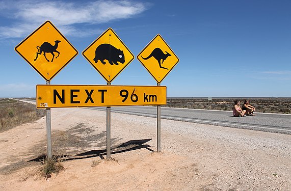 Warning signs on the Eyre Highway for camels, wombats and kangaroos over a 96 km (60 mi) stretch

This image is freely licensed or in the public domain, which means it can be reused by anyone for any purpose (subject to any licence conditions).
See also
RELATED PORTALS


(Northern
Territory) |
SISTER PROJECTS
The following Wikimedia Foundation sister projects provide more on this subject:
-
 Commons
Free media repository -
 Wikibooks
Free textbooks and manuals -
 Wikidata
Free knowledge base -
 Wikinews
Free-content news -
 Wikiquote
Collection of quotations -
 Wikisource
Free-content library -
 Wikispecies
Directory of species -
 Wikiversity
Free learning tools -
 Wikivoyage
Free travel guide -
 Wiktionary
Dictionary and thesaurus